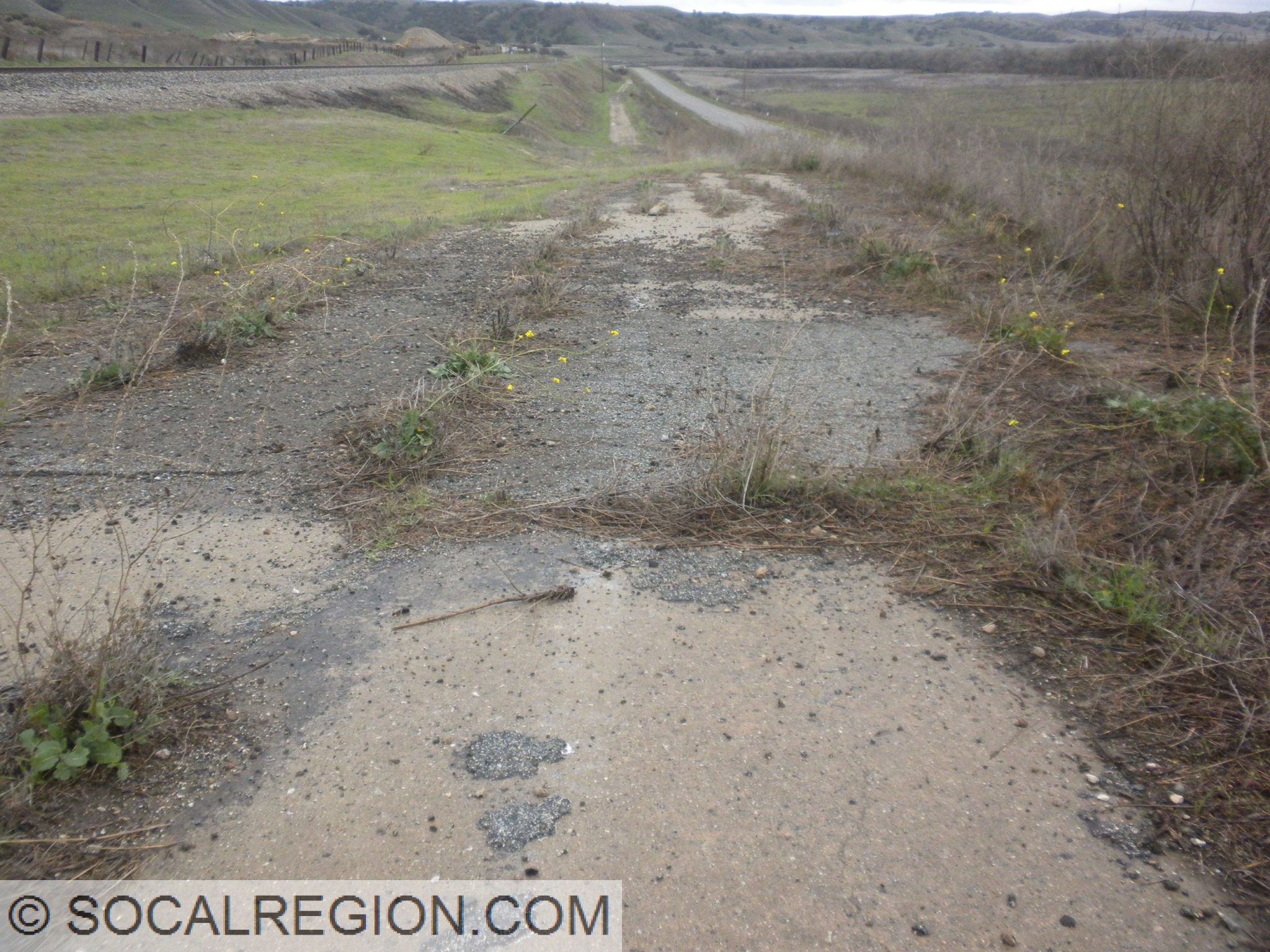
In July 2010, I was able to go to Baja California with a friend. Part of our route traversed Federal Highway 2 (Mexico), which suffered some damage from the April 2010 quake. Hwy 2 had been repaired but the adjacent old alignment had not been. I was rather amazed at the amount of offset from this earthquake. I observed about 2′ of horizontal and about 5′ of vertical offset at the highway crossing.
East of the fault, bridge embankments on the Hwy 2 Mexicali Bypass show signs of settling.Offset right of way fence next to Hwy 2.Old alignment of Hwy 2, now offset by about 2 feet horizontally and 5 feet vertically.Side view of the old alignment showing the vertical offset.Breaks in the soil to the north. Two distinct scarps can be noted here.At the break, the old alignment now has a steep ramp and crack.
A M5.1 earthquake occurred at 9:09PM on March 28, 2014, located 1 mile easy of La Habra, CA, or 4 miles north of Fullerton, CA. The event was felt widely throughout Orange, Los Angeles, Ventura, Riverside, and San Bernardino counties. It was preceded by two foreshocks, the larger of M3.6 at 8:03pm. The demonstration earthquake early warning system provided 4 second warning in Pasadena.
There have been 23 aftershocks as of 10:00PM on March 28, the largest of which was a M3.6 at 9:30PM, and was felt locally near the epicenter. The aftershock sequence may continue for several days to weeks, but will likely decay in frequency and magnitude as time goes by.
The maximum observed instrumental intensity was VII, recorded in the LA Habra and Brea areas, although the ShakeMap shows a wide area of maximum intensity of VI. The maximum reported intensity for the Did You Feel It? map was reported at VI in the epicentral area.
This sequence could be associated with the Puente Hills thrust (PHT). The PHT is a blind thrust fault that extends from this region to the north and west towards the City of Los Angeles. It caused the M5.9 1987 Oct. 1 Whittier Narrows earthquake.
Previously, the M5.4 2008 Chino Hills earthquake occurred in this region. It caused somewhat stronger shaking in Orange County and across the Los Angeles Basin.
The moment tensor shows oblique faulting, with a north dipping plane that approximately aligns with the Puente Hills thrust.
The demonstration earthquake early warning system provided 4 second warning in Pasadena.
On April 4, 2010, a 7.2 earthquake struck the northern Baja California and Southern California region. I was in Oceanside at a friends house at the time. Initially, I didn’t feel it and thought the others at the party were joking. We had been talking about the Northridge Earthquake earlier in the day. Once I stepped out onto the patio, I felt the ground moving. I knew it was large but farther away. My first thought was – What just happened to Los Angeles? Instead of Los Angeles, it was the Mexicali/Calexico area that got hit the worst as it was much closer to the epicenter.
Map showing the earthquake and affected area.
Wanting to survey the damage to the roadways in that area and see if any of the old bridges were damaged, I headed out the following weekend. As it was also springtime, parts of the desert were in bloom. The ocotillo in particular had a beautiful display of flowers. To get out there, I followed Hwy 80 out to the Desert View Tower. After talking with Ben, the owner, I headed out to Calexico following Hwy 80 and Hwy 98. I was hoping to see cracks in Hwy 98 from any fault movement but did not find any.
Blooming ocotillo along Hwy 98 in the Yuha Desert.Closeup of the blooms.
In Calexico, many buildings were damaged with a large portion of the older downtown area closed off until the buildings could be stabilized. The biggest damage I saw was at a hotel in the northwestern end of downtown. Parts of the walls and roof had collapsed.
An empty and closed off downtown Calexico.Partially collapsed roof and wall in Calexico.Damaged Hotel De Anza in Calexico.Front of Hotel De Anza showing some damage.Partially collapsed facade of the Hotel De Anza.
Returning from Calexico, I stopped at a few bridges to see the fill on each side had settled, causing some cracking in the pavement. Additional cracks were spotted at the New River crossing on old US 80. Overall, the highways were lightly damaged with some concrete broken at some bridges.
Typical settlement repair at the Westside Canal bridge on State 98.Settled dirt at the edge of the Westside Canal at State 98.Both sides of the New River trench show settlement on US 80.Cracked pavement on old US 80 at the New River.Cracking in pavement and soil from settling at the edge of the New River trench.
I took a trip out to the beach today (May 2). It has been a while since I’ve gone and I wanted to test out my new zipperless wetsuit. I decided on the beach between La Jolla Shores and Black’s Beach. The scenery is great and the beach is far less crowded. So, I put on my wetsuit, grabbed my bag, and headed out on the motorcycle to La Jolla. Parking is so much easier there when you don’t have to worry about a car. It seems every time I go out there I am left wondering why I don’t go more often.
Scripps PierSmall Sea Arch with musclesTide PoolsOne of the Starfish I found.A Sea Slug? This little creature was quite colorful too.Another Starfish, this one out of water.
The tide was out when I got there, allowing for a very exposed and wide beach. The waves were pretty decent in spots, with the surfers getting plenty of use out of them. Just north of Scripps Pier, there is a rocky area with some tide pools. I stopped by and checked them out on my way. Today was about exploring and having fun, so why not? I found a small sea arch with quite a few muscles clinging to it. I also found a few starfish and some sort of sea slug. Once past the rocks, it was time to find a spot to go swimming. I’ve been wanting to get in the water with my new wetsuit. I’ve heard that zipperless suits are warmer in the water. This style of wetsuit is quite popular with the surfers around here as well. I found a spot to leave my gear, and I headed out to the water. Initially cold, it ended up being quite comfortable in my suit. I didn’t get the cold rush of water into the suit through the rear zipper, this one not having a rear zipper. It felt great to be out in the water. The ocean is cold here, but fairly clear. I think next time I’ll bring my fins and play around some more in the water.
My swim spot. A very wide, yet nearly empty beach in San Diego… this is the life!Heading north along the cliffs.
After my swim, I wanted to explore the beach some more. I headed a bit further north until I reached a canyon that had running water coming from it. I stopped to check out the stream and ended up seeing some surfers with their boards coming out of the canyon. Upon closer investigation, I saw they were using a rope to climb the steep entrance from the beach into the canyon. I decided to explore this canyon a bit. Heading into it was pretty easy, though muddy in places. I was glad to be wearing my wetsuit booties. Much easier to walk in than bare feet. The trail was fairly well worn, though very narrow in places. About 100 yards into the canyon, there was a sizable waterfall. I wondered how I would get past it until I saw a surfer with a long board make it through rather easily. It turns out there was a very well worn series of “steps” in a narrow passage through the sandstone. Once I made my way up these, I got a better view of the upper reaches of the canyon. I decided to head back down, not wanting to end my beach time just yet. Heading down was a little easier than going up.
Surfer on his way down the trail.Inside the canyon, deep and narrow.A seemingly impenetrable sandstone wall.“Surfers Steps”. Somehow they manage this carrying their boards.Almost back to the beach.
At the bottom of the canyon, I headed back toward the motorcycle. I stopped for another swim at the same spot I did heading up. I just needed another soak in the ocean. After my swim, I headed over to the rocks where I saw the tide pools earlier. The tide was already coming up, so the outer reaches were flooded. As I got closer to the pier, the beach was a lot busier. It seems like the rocky area is a barrier to some. It sure didn’t stop me today. Overall, it was an enjoyable swim, a fun hike, and I definitely will return sooner. As I live in San Diego, I should at least take advantage of the beautiful beaches we have here in “America’s Finest City”. On my way home I stopped for a burger at the In-n-Out in Mission Valley, where the guy at the counter was rather inquisitive as to why I was wearing a wetsuit. He definitely enjoyed seeing me in my wetsuit. After getting home and doing a bit more research, the canyon I walked up ends at the parking area for the Torrey Pines Glider Port.
My friend Jake and I left San Diego rather early, about 4:30 am. Our goal was to get up to the San Luis Obispo area as early as we could, so that we could take our time north of there to the Gilroy / Hollister area. It seemed to have worked. As we were making pretty good time, we decided to check out some old alignments of US 101 a bit earlier. We followed some alignments near Gaviota and Buellton, both of which had good sections of old concrete. After that, we didn’t make any major stops until north of San Luis Obispo.
1930 Bradley Bridge.Piers for the original Bradley Bridge, just upriver.Pre-1939 alignment of US 101, with single-slab concrete and white striping.
At Bradley, we stopped at the large bridge over the Salinas River at the north end of town. It was built in 1931, replacing a multiple through-truss span built in the 1910’s. Much to our surprise and enjoyment, we got a much needed break from the rain here. The break was just long enough to walk the span and take many photos. I hadn’t had the opportunity to really view the bridge, so this was quite welcome. Once we left the bridge, we took the old alignment of 101 south back to the freeway, taking a slight detour onto an even older alignment, bypassed in 1939. Most of it was still fairly well paved, complete with sections of double white striping. One spot, however, proved to be a bit trickier. Some years in the past, a small landslide took out a portion of the roadway. A short dirt bypass was made, which was rather muddy after all the rains. I got of the car to scout the roadway ahead, to see if it was passable. I decided it was, and the car was able to make it. It did slide a bit down the slope, but not to worry, it wasn’t a problem. By the time we got back to the main road, the tires had acquired a thick ring of mud, almost a new tire in itself. Hey, it’s a rental car right?
Original CSAA FAP sign from 1929. Note the diamond on top.an Lucas Bridge – from 1915, at least the southern two spans anyway.
Getting back to current US 101, we continued north to San Ardo, where the old highway crossed the river again. The bridge here is very similar to the North Bradley Bridge, built in 1929, but without the old railing. In 2001, the span was seismically retrofitted and the old railing was removed. One thing that was not removed, and only discovered by us on this trip, was a 1929 FAP sign, complete with a CSAA yellow diamond. These are rare to find out in the field, so it was quite something to see. This section of the road, from San Ardo up to San Lucas, was the last section of two-lane highway on US 101 from San Francisco to Los Angeles. It was bypassed in 1971. It still makes a nice detour from the main highway, with little traffic to deal with. At the north end in San Lucas, there is another old bridge nearby, crossing the Salinas River on Lockwood-San Lucas Road. That bridge, from 1915, is a through-truss span. Some of the girders had Carnegie Steel stamped on them.
Still heading north, we arrived at Gonzales, where we diverged from US 101 to see another old bridge over the Salinas River. I first found this bridge in 2001 on my first bicycle tour. I wasn’t planning to take that route at the time, but had to make the detour as there was no other route available. The bridge, a 1930 through-girder span, reminded me of another bridge that was near where I used to live. Through-girder spans are rare, usually used by railroads not highways. Instead of returning to US 101, we decided to change course, and follow the River Road on the west side of the valley. I hadn’t been there before, and it took us north. So, why not take a different path?
We crossed back over the river near Chualar, and went back to US 101. We stayed on it until the south end of Salinas, where we exited onto Abbot St, the old alignment and business route. The southern end of Salinas had the distinction of still having old US highway shields in place until the early 2000’s. The signs are gone, but the porcelain business banners remain. We found two of them, one northbound and one southbound. Heading through Salinas started off alright, but as we got closer to the center of town, things went downhill – fast (or was it slow). Traffic increased, roads turned in confusing directions and we didn’t have a map. Still, we managed to get through town and onto the road we wanted – San Juan Grade.
Old sign with the straps still there for the old US shields in Salinas.
San Juan Grade Road is the original alignment of US 101 from Salinas to San Juan Bautista. Having been bypassed in 1932, the roadway still retains most of its old feel. It wasn’t widened, and much of the original 15’ concrete is still visible. A few of the curves were straightened, but even that appears to have been done long ago. A lot of the old wooden guard railing is still in place, mostly on the north side of the summit. South of the summit, a few bridges with pipe railing are still intact. Rain and fog prevented a lot of good photos from being taken, but we still got a few. On the north side, in San Benito County, more of the old concrete was preserved. It was good to see such an old highway in as good a shape as this was. At the north end, where it met old SR-156, there was an old white directional sign from 1959 which was on our list of things to see. Having taken care of that, we headed east to Hollister. It was time for some geological tourism.
Old concrete and railing. A very nice mix.Sometimes, rocks will fall, this one was strangely stopped by the railing. Must not have been going fast.More old concrete on San Juan Grade.Nice old sign from 1959.
Hollister, not the town from which the clothing comes from, is a growing suburb in the southern Bay Area. It still has a lot of farms surrounding it, and still retains a lot of its old downtown. It also is well known to geologists. The Calaveras Fault, a branch of the San Andreas Fault, runs right through town. This particular segment of the fault creeps. Most fault move in large jolts, known as earthquakes. This moves along like a conveyor belt, but much slower. The results can still be quite dramatic. Along many streets in the northwestern end of Hollister, there are offset curbs and sidewalks. A portion of an old fault scarp is also visible, usually as an abrupt rise in the street. All the roadways crossing the fault have fractures, bumps, and lots of patching. The earth waits for no one, and is more than willing to show its power. Sometimes structures lie atop the fault, and they too have been made a bit askew. Some are just cracked, while others are twisted out of shape. I noticed one such structure, on Suiter St, that was so badly cracked, I wondered how much longer it would stay up. It was certainly proof positive why the Alquist-Priolo Zoning Act was created.
Roadway cracking and bent curb on 7th Street next to Dunne Memorial Park.Note the columns. House is a bit twisted from the fault creep, on 4th St.More en echelon fractures on 5th St.4th St, notice the bend in the curb and cracked panels in the sidewalk.Pavement has to be redone often here, it also sags a bit.Offset here is about a foot.Once straight, now bent.Through Dunne Memorial Park, the low fault scarp becomes quite visible.
After seeing all we could see of the Calaveras Fault, we headed out of town, first following the new alignment of Hwy 25. The new bypass runs to the east of town, connecting two places that 25 used to turn at. From there, it was on to Gilroy, where we stayed for the evening. Another adventure awaited us the next day – the Big Sur Coast!