Walking today, I saw that the former San Diego Electric Railway tracks in the median of Park Blvd seem to be staying put. Construction is underway for a “busway” which is tearing out most of the old track and poles. However, at Howard Ave, the tracks are being left in place and reburied beneath the new median. Why this is the case here and not anywhere else is something of a mystery. Hopefully it marks a trend to keep some of the old infrastructure in place instead of destroying it.
Section of rail removed at Howard Ave.South of Howard Ave to near Polk Ave, the old rails remain.
Before the Metro Gold Line Eastside Extension was opened, I was contacted by Nobuho Nagasawa. She was commissioned to create the artwork for the 1st St and Soto St Metro Gold Line station. She was looking for maps of the area surrounding the 1st / Soto station and found my website on the East Los Angeles Interchange. After searching my collection, I did find two maps that covered that area. The Los Angeles and Alhambra 6′ map sheets from the late 1920’s covered the area she needed with the right resolution. They were then scanned in at high resolution and sent along to her for use. As they were USGS maps, they were within the public domain and easy to transfer.
As I had obtained the maps from a geologist that had marked them up, cleaning them up prior to scanning was essential. I got most of the marks off, but some still remained. It seems they were just enough to “watermark” the maps as indeed from my collection. While not intentional, it did help me identify the maps when I saw them in a video on the opening of the line. In December 2009, I was finally able to see the station in person. The sheer size of the artwork created from these maps was astounding. A portion of a 6′ USGS quad sheet had been transformed into a 30′ x 60′ map going from one side of the station to the other.
The original and the artwork. Map sheet being held is the Los Angeles 6′ map.
Overview of part of the artwork display. Stairs lead to the platform level.
Western half of the map showing the Los Angeles River and part of downtown.
Central portion of the artwork.
Closeup showing some of the marks left on the map. Note the “36” circled in pencil.
Markings for Pliocene Rock (PLIO) and a fault line.
I wish to thank Nobuho Nagasawa for allowing me the privilege of contributing to the Los Angeles Metro Rail system. It gives me great pleasure to know that something I have in my collection is seeing use in a way I never expected.
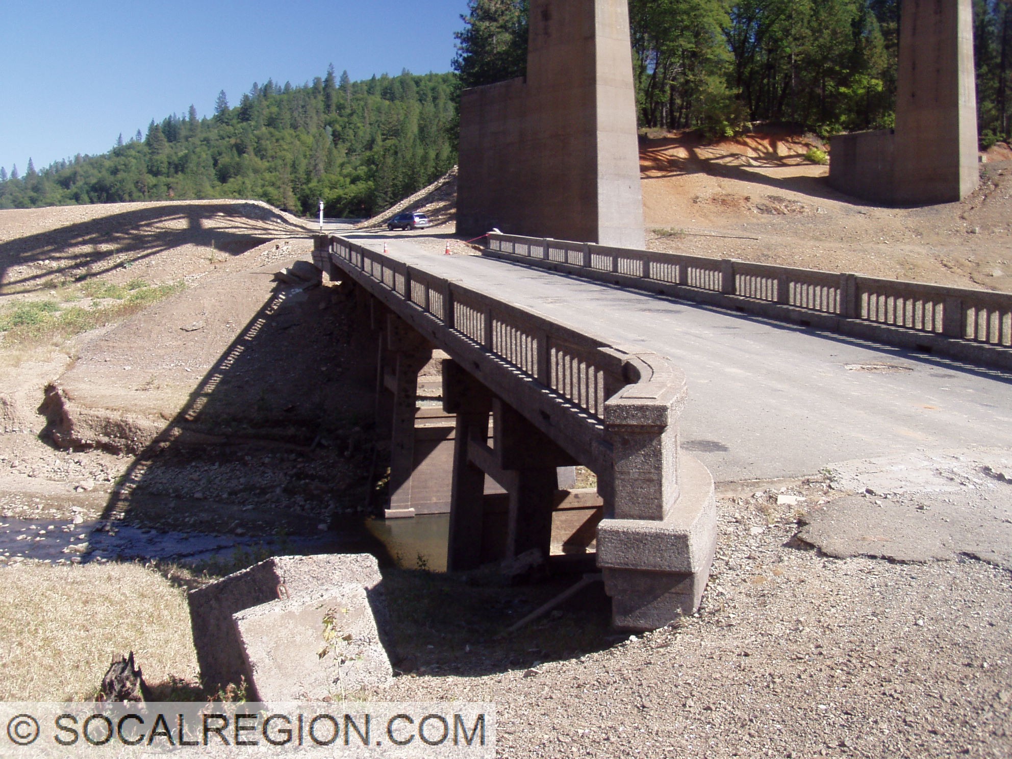
In October 2008, Lake Shasta was dropping to near historic lows. I took a trip up there to hike many of the exposed alignments. I also got out in the water in my wetsuit when I needed to. The whole trip was a lot of fun. Here are the photos from that trip.
Salt Creek Inlet and Lakehead Area:
Pit River Area:
Where US 99 goes into the lake on the south bank near the Pit River Bridge.
I know it has been a long time since I’ve updated. Well, been a while since I’ve gone on something really worthy of writing about. The past few days, have been worthy.
On Thursday, November 3, 2011, I set out on a new great adventure. My goal for the first segment of the trip was Vancouver, British Columbia, Canada. My method of travel was Amtrak. Starting at 6:10am out of San Diego’s Santa Fe Depot, I took the Pacific Surfliner to Los Angeles Union Station. There, I waited in the TRAXX Lounge, which is just for sleeping car passengers of train #14. Train 14, the Coast Starlight. The Starlight is the premier Amtrak train in the West. Every time I’ve taken the train, the service has been splendid. This time, it was even better. Using Amtrak Guest Rewards (something I highly recommend joining), I obtained a deluxe bedroom on the train, which is quite decent for one person.
Views from the train were, as always, quite spectacular. The California coast just can’t be beat. Near Gaviota, I saw two of pods of dolphins. While on the train, I met people from all over. Wisconsin, Vancouver, Minnesota, even San Diego numbered among the places. We had our first wine tasting of the trip just north of San Luis Obipso, consisting of California wines, some from the local area. These are always a lot of fun, as I get to interact with more of the people on the train. I tend to talk about some of the geology and history along the way, like a tour guide.
After the wine tasting, we made our way through the Salinas Valley, where I spent some of my time in the Parlour Car. Slowly getting more tired, I went back to my room for a while. I chatted a bit online with some of my friends, listened to music, and then went off to dinner in the Dining Car. I had the BBQ ribs, which were quite good. A few people came by and said that it looked good as well. I saw others having lasagna, which was my other choice.
After dinner, I went back to my room to listen to some music before the movie began. In the Parlour Car, there is a movie theater downstairs. I watched “Limitless” which I hadn’t heard of before. It was pretty good, and took up the time from near San Juan Bautista all the way to near Hayward.
Once the movie was over, it was time to get some sleep. I went back to my room, after the bed had been set up. It was quite a nice bed too. Not that thick a mattress, but comfy enough. I laid down for a while, finally getting to sleep just past Martinez. The next thing I knew, we were north of Dunsmuir! Again, I slept through the Sacramento River Canyon. Oh well, perhaps I’ll see it on the way south. I finally got up near Mt Hebron Summit, where there was quite a bit of fresh snow on the ground. By the time we got to Klamath Falls, the snow was gone. While there was no snow, it was still really cold. I think it was in the 30’s outside. I still stepped out of the train. I had finally reached Oregon. Only one more state to go.
After Klamath Falls, we made our way over the Willammette Pass. The higher we climbed, the more snow we saw. It wasn’t quite enough snow to hide the fairly deep pumice layer capping most of the cuts along the railroad. It looked to be about three feet deep toward the summit. I suspect the pumice was from the Mt Mazama – Crater Lake eruption, about 6.6 kya. The section of the tracks over the pass was fun as always. Other passengers told their train stories as I pointed out various features along the way. My favorite stretches of track is located a few miles below the summit, where the train passes through a tunnel, then a curved trestle, and then back into another tunnel. The snow and the fog made the crossing of the Cascades a whole lot more entertaining. As we got lower in elevation, the fall colors came back. It was a bit past peak color, but still quite spectacular.
Our next wine tasting was just north of Eugene, where I had quite an interesting conversation with another passenger. I talked a bit about the history of US 99 and the railroad line through the Willamette Valley, where he talked about the Civil War and how the railroads played into the various battles. It was quite entertaining. I learned a fair bit, and he did too.
By Portland, I had wanted to get out and stroll about the station grounds. Portland Union Station is quite a large station and very nice. As we had a longer layover, I decided to get up to the Broadway Bridge and take some photos. I saw quite a few cyclists on my short walk, most with fenders on their bikes. Some of them were in full gear (tights and long sleeve), others just in street clothes. Most of them looked like they were commuters. After my walk, I made my way back to the train, and it was time to depart. Almost to Seattle!
For dinner, I decided to go with the Parlour Car. The menu is smaller, but usually good food. It was pretty good. After dinner, I went back to my room, enjoying it for the last time. As we approached Seattle, it got darker, and sightseeing was getting tougher. I still managed to see the Tacoma Narrows Bridge and the skyline of Seattle as we approached.
Finally, Seattle! After gathering my gear, I got off the train and headed out to my hostel. It was only two blocks from the station, which made things easier. I had just two bags, but they were quite heavy. After getting quickly settled at the hostel, I headed out. I had wanted to go to the Space Needle, and knew the way to get there. After making my way over, I found out… it was closed! Bummer! Well, I decided, what the heck, gotta do something else then. So I looked up various gay bars in town, decided to head over to the Seattle Eagle. It was a bit of a walk from the Monorail station, but not too bad. I felt a bit bad, normally I go out in full gear, but this time, only had my leather combat boots on. It would have been too much to go back to the room and change into either a military uniform, or my leather outfit. But hey, I still wanted to go. So, I found the place, got a drink, and hung out for a while. It was still fun. I found out it was leather night there… DOH! Hey, there is always another time. Once I was done with my drink, and had talked with some people there, I headed back to my room. I had to get up early the next morning to catch the train to Vancouver, and didn’t want to stay up too late. I walked the whole way back, and ended up stopping by Columbia and 1st to visit the last remaining original US 99 shield in Washington. Another day of adventure was ahead. This time, to Canada!
In 2011, the newest Metro Rail line in Los Angeles will open. Running from downtown Los Angeles at 7th St/Metro Center station, to Culver City at Venice Blvd / Robertson Blvd, it will be the first new line to open since the Metro Gold Line in 2003. This bike ride was to follow that from Culver City to Santa Monica Blvd. I wanted to see what was left of the old Pacific Electric line, and photograph it. It also made for a nice bike ride. The Metro Expo Line (no color for it yet) was set to open this year, but numerous delays changed that.
The line west of Culver City, however, has been a bit more of a challenge. The section from Culver City to Sepulveda Blvd has been the most contentious of them all. A small group of people in the Cheviot Hills, where the rail line will run, have fought the construction of the line for so many reasons. None are valid reasons, as they are just plain silly from the start. One of their biggest complaints, as seen in the sign pictured, is that kids and trains don’t mix. Now… to that I agree. They don’t. Kids shouldn’t be playing on active tracks, much for the same reasons they shouldn’t on any one of the major thoroughfares in the area. It should be simple, teach the kids to not play in front of trains, but to hold up a major rail line for it? They take the stance of “build it right, or don’t build at all”. All or nothing is a rather poor way of doing things. Kind of sad really, but hey, the line will get built despite them. Yeah!
Looks like the cars just pile up every time a train comes by?
They don’t mix, but they can try to blend! Sorry for the blur.
Now, back to the bike ride! So, after doing a bit of research using Google Maps and Street View, I found free parking right near the old Helms Bakery. Perfect, right near where I wanted to start. After parking and getting the bike ready, it was time to go. The weather was fairly decent, though a bit on the cooler side near the beach. I started off heading to Venice Blvd, then onto Exposition Blvd. Just before National Blvd, I saw the first tracks of the day. The first thing I noticed was the bonds between the rail segments. These were original Pacific Electric tracks from the 1920’s. I took some photos, and moved on. Heading west from here, I went under the 10, then headed west through the Cheviot Hills area – remember them? Well, ignoring them and their silly signs, this is the best section of the whole line, certainly the most scenic. About halfway through the big cut here, there is a pedestrian bridge. It makes a great place to get photos, and will be a good place to watch the trains in 2015.
West towards National Blvd.
Rail bonding. Rails are from the 1920’s.
Looking northwest from the bridge. This the the deep cut through the Cheviot Hills.
After that, the next major hurdle was Overland Ave. There were some remains of a crossing signal there, so I got some photos. The rails were cut at the crossing, but were still there on both sides. After Westwood Blvd, I got a different idea. There was plenty of dirt between the rails, and no plants. As railroad tracks usually have lots of thorns around them, I was a bit leery of doing this. I still did it anyway. After all, it is a cross bike, gotta ride dirt at some point! It was pretty smooth overall, with some muddy spots. Just beyond Military Ave, the tracks ended, for a while. The east switch for Home Junction still remained, but after that, no more tracks. At Sepulveda Blvd, only the guard rail for a crossing arm remained. From here west, there wasn’t as much to see. I was surprised to see the tracks still in place, along with the remains of the west switch for Home Junction, at the edge of a parking lot west of Sawtelle Blvd. They just paved right up to the north rail.
At Westwood Blvd.
A ready made bike path? Certainly plenty of space for double track.
Crossing at Military Ave.
One of the few crossings with rails still intact.
Eastern switch at Home Junction. Expo Line continues straight ahead.
Western switch at Home Junction. I-405 is in the distance. Expo Line is to the right.
After Pico Blvd, Exposition Blvd picked up again. This time, even less remained of the tracks. From what I could tell, they had been pulled up long ago. No trace remained at the road crossings, only the occasional crossing signal or pole remained. At Centinela Ave, it was time to go over to Olympic Blvd. This ride isn’t about the PE after all! Olympic Blvd is an old State Highway, former Route 26. West of Centinela, the roadway turns into a four lane divided roadway, complete with concrete. I had only driven the roadway before, so this would be a good opportunity to find a date stamp on the concrete.
1948 date stamp on Olympic Blvd.
Just after Cloverfield Blvd, I found two things I had been looking for. The rail line crossed Olympic here, with the rails still in place, and there was a date stamp in the concrete. The stamp was from 1948, a bit earlier than I had thought, as I saw a 1958 stamp in a curb just before Cloverfield Blvd. I continued down Olympic Blvd as far as Lincoln Ave. Why that far? Well, that intersection, or at least the modern equivalent (the 10 freeway has modified things around there), was the west end of US 66. US 66, the Mother Road, ending at such a bland location? Yes. It never ended at Ocean, never mind what the signs may say. It always ended at the intersection of Lincoln Ave and Olympic Blvd. This intersection was formerly the junction of US 101A, SR-26, and US 66. The last two ended here, the first continued north to Malibu and Oxnard. After making some zigs and zags through central Santa Monica, I made it to Ocean Ave. Finally, the coast! It was a good place to take a break, enjoy the view from the cliffs, and figure out my next move.
At Barrington Ave.
East on Olympic. Nice landscaped median and concrete roadway.
Expo Line crossing Olympic. Note the gutters on the rails in the median.
My bike at the Palisades.
Fog finally clearing. Note the abandoned and eroded path.
Sort of correct, Santa Monica is the end, just not Santa Monica Blvd and Ocean Ave.
I decided it was time to take some photos. There was a plaque for Will Rogers, and a sign stating it ended here. As stated before, it didn’t. Once I had taken my photos of the Will Rogers Highway plaque, I headed on south. It was time to hit Venice and see what remnants of the Pacific Electric I could find. I followed Ocean Blvd down until I could connect to the beach path. It wasn’t a busy beach day, so taking the path wasn’t a bad idea. Before I got to the beach, I found some reminders of why I like to ride there – SURFERS! Yes, it is always a good day for a ride here. The trouble with the path is sand. Lots of sand. It is a beach path after all! It wouldn’t be so much trouble, if it weren’t for the very sharp curvy nature of too many sections of the beach path. Seems to go out of its way to put curves in places there should be none. Just gotta take it slow. After I got as far south as central Venice, I left the path. As it turned out, I was right at Venice Blvd.
Will Rogers Highway, nice place for a plaque.
Tracks at Broadway St in Venice. Yes, the PE lives on!
I took Pacific Avenue for a while, looking for traces of the PE. I found some, a building that had loops for hanging the overhead wire. After a while, I moved over to Main St, and followed it to the south end of Santa Monica. I was searching for a train station, but did not find it. Next time perhaps, when I remember to bring the address! No matter, I headed back south, following 2nd St this time, which eventually turns into Electric Avenue (yes, I did rock down to…. Electric Avenue, but I didn’t take it higher.) This follows another PE line, with some tracks still extant. There were two small sections of track, at Broadway St and Westminster St. I got my photos, and headed onto Abbott Kinney Blvd, which has sharrows. I took it just for that reason.
After roaming through Venice, it was time to get back to the car. No rush, but I decided to take the shortest route – Venice Blvd. The roadway is wide, with overall decent paving, and bike lanes both directions. Winds, the seemingly slight downhill, and my energy at that point in the ride seemed to meet. I kept a decent pace down the road, averaging about 26 mph, sometimes up to 30 mph. Not bad, I thought, as I noticed I was keeping up with traffic. With that, the ride took less time than I had thought it might, and I got back to the car just shy of two hours later than I started. Overall, a fun ride. I saw most of what I set out to see, with few problems. The future of Los Angeles, it seems, lies in its past. Where there were trains before, there will be again. Instead of building a city as they did, they’ll keep it moving.