This is the first part of a new series on SoCalRegion where we will discuss various topics related to roadways, their design, signage, as well as other features to help assist all road users in traveling throughout California. Many of these features exist in other states, but some have a different take on things.
Roadway striping comes in a few different colors and designs. Each of these have a meaning. Even without using signs, you can use striping to help determine what is going on with a roadway. Using these clues can also help aid with navigation in unfamiliar areas.
The Basics
Standard double-yellow striping
Let’s start with the basics. Two basic elements of striping are common throughout the United States – yellow means dividing opposing traffic and white means same direction of traffic. These colors remain nearly universal throughout all 50 states. Double striping, no matter the color, denotes a “no passing” or “no crossing” location. Passing, assuming the roadway is two lanes wide, can be done when the stripe on your side is broken. When the whole stripe is broken, both sides can pass.
Divided Roads
Two sets of double yellow stripes dividing a roadway
Multilane highways are divided in a variety of ways. When it comes to striping, there are three main types. The first is still the basic double-yellow striping. When a roadway needs a bit more of a divider, two sets of double yellow stripes are placed. These are considered “painted barriers” and are not to be crossed in any way. Some of these roadways have breaks in the striping, usually on one side only, to allow for turns onto side streets or driveways.
Common center turn lanes are another way to divide a roadway. These can exist even on two lane roadways but are more common on multilane roads. These center lanes are striped with a solid yellow line on the outside and a broken yellow line on the inside. These lanes allow both directions to make left turns.
Common turn lane on a two lane roadway. A sharrow is also visible here.
Freeways
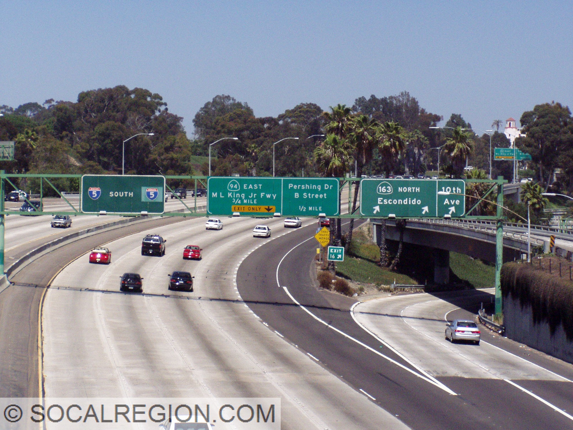
Freeways, while the striping is color coded the same way as regular roads, do have some different styles and meanings. Exit Only lanes, meaning lanes that will exit a freeway shortly, have something Caltrans calls – Elephant Tracks. When a lane is going to leave the freeway, the striping changes in thickness and frequency. These stripes are wider and a little more frequent than regular lane striping. It is one of the visual cues that is designed to help motorists determine if they are in the correct lane, regardless of signage.
Souith at the 163, the “Four Level” interchange in San Diego. Here you can see the transition to exit only striping for State 94 on I-5. Also note the change at the gore point for the shoulder striping.
At the exit itself, the shoulder striping in California has a unique modification. Designed to aid motorists in times of reduced visibility, the shoulder stripe has a break at the exit and flares out to mark the exit. In areas subject to heavy fog, there is an additional exit cue – reflectors. These are off to the side of the shoulder striping at intervals and are in rows of three, two, then one at the exit.
Where most freeways have only one HOV lane, this has two from Adams Ave south to I-105.
118 through the northern San Fernando Valley near Reseda Blvd.
HOV lane striping is another variation found on California freeways. Until a few years ago, these lane were, in general, striped with a double set of double yellow lines, acting as a painted barrier. There were variations based on available space as well. Specific entry/exit points where marked with broken white striping. These stripes are now being changed to double white lines with broken striping at the entry/exit points.
As you can see, there are many ways to determine what is going on with a roadway without looking at signage. Striping can help guide road users in ways signage cannot. So, when you are in unfamiliar territory or in conditions where you can’t see the signs, use these clues to help direct you to where you are going. The stripes are there to help!
Roadways and their rights-of-way are marked in various ways. Originally, roadway rights-of-way were poorly marked, and as a result, changed quite a bit. These changes made travel sometimes rather confusing as the roadway path may have changed before the map the traveler used changed. This sort of problem also cost the State quite a bit of money as they had to not only correct the problem, but also deal with the potential land costs of a new alignment.
Starting in 1914, the California Highway Commission came up with a plan to mark the right-of-way in a more permanent manner. Their solution – a “C-Monument”. While not the official name, which is simply “survey monument” or “right of way monument”, it aptly describes the marker. These monuments would be placed at the edge of the right-of-way at intervals along tangents (straightaways) and at curve points (BC and EC or Beginning of Curve and End of Curve). Optimally, these monuments would project about one foot above the ground with the C facing the roadway. The C stood for California, as in the California Highway Commission. At the top of the monument, a copper plug was placed to help guide surveyors. Per the January 1949 Division of Highways Standard Specifications manual, “Monuments shall be set firmly and vertically in the ground to a depth of at least three feet.”
Old C-Monument State Highway Right Of Way marker from 1930.
C-Monument along a 1930’s alignment of US 6 in Red Rock Canyon.
The C-monument was actively placed and used for many years, though when it finally was out of use seemed to vary between districts. In San Diego County in District 11, for example, they were used along freeways constructed in the mid to late 1950’s. Los Angeles County, within District 7, seemed to stop using them sometime in the late 1930’s. Today, the monuments that remain are still valid survey monuments. While not placed anymore, Caltrans, as well as local agencies, still use them. As such, please do not disturb or collect them if they are still in place. Finding them along a roadway also doesn’t automatically make it an old State Highway. Some counties also used these monuments as they were a part of the standard plans for any project that involved state or federal dollars, such as Del Dios Highway between Lake Hodges and Rancho Santa Fe in San Diego County.
Finding these monuments is actually quite simple. Typically, roadway rights-of-way ranged anywhere from 100′ to more than 300′. Find a curve in the roadway you are looking at and look for one on either side of the roadway about 50 to 150′ away from the centerline of the roadway. In mountainous areas, the uphill one tends to be easier to spot than the downhill side. Fence lines, power lines, and other similar features can be used to indicate the right-of-way edge. As they can still be used today as survey monuments, some are marked with paddles or other objects to make a surveyors job easier when locating them. Placer County uses a white “R/W” paddle. Caltrans District 9, at least in Inyo County, uses orange poles as location markers.
On August 12, 2017, I will be hosting this websites first highway tour in the Cajon Pass area. This tour will cover the roadway from Verdemont to Cajon Summit. Some portions will have to be skipped, unfortunately, due to fire-related closures. The start of the tour has changed from the initial announcement. It will now begin at Devore, in front of Tony’s Diner at 18291 Cajon Blvd, San Bernardino, CA 92407 at 8 am. Please do not park in their parking lot. There is plenty of on-street and off-street parking in the area.
[wpgmza id=”1″]
After a brief introduction, we plan to leave at about 8:30 am. The tour will stop at the following locations:
Verdemont (backtrack)
Cajon Blvd (at the freeway)
Kenwood Ave
Keenbrook
Blue Cut
Debris Cone Creek
Cajon Junction
Cajon Summit
Additional stops may be added if needed. I strongly recommend bringing water and snacks as there are few water/food stops along the route. Please RSVP if you plan to attend this tour. Again, we will be leaving the starting point no later than 8:30 am. Please RSVP no later than August 11 so that I can get a rough number of how many will attend. I look forward to seeing you out there!
It has been a while since I’ve added to my US 6 tour. For quite some time, it “only” went to Tonopah, Nevada. While that town makes for a good end point, it left quite a bit of very interesting and scenic highway out of the tour. US 6 across Nevada is one of the emptiest highways in the lower 48 states. It gives travelers and geologists alike a very good cross section of the Great Basin as well as a look at the mining past of Nevada. With that in mind, my US 6 tour now extends to the Utah / Nevada State Line, covering approximately 620 miles of roadway.
Bridges and culverts can be great indicators of when a highway was built and by whom it was built. In California, there are a few different styles of railing which can be used to put a relative date on a particular bridge when they don’t have date stamps on them. Other indicators may be used when the bridge rail has been modified or even replaced by modern rail. Styling elements on the superstructure vary depending on age. Older bridges tend to be more ornate than more modern structures. This page will serve as a guide to these styles and help to increase understanding of what goes into the design of these bridges.
Bridge Types
The type of bridge built is something that is more dependent on location rather than age, though that can make a difference to an extent as well. Older bridges varied quite a bit in their design, with steel truss and concrete arch spans being more common than today. Bridge types vary quite a bit even today, but tend to conform to a few simple concrete designs.
Let’s start with location for a bridge. Modern bridges are built to conform to the roadway alignment, to put it simply. When a roadway alignment is chosen, it is based upon many factors, but when a bridge is needed for the roadway, it is built as a part of that alignment. In contrast, earlier bridges were built where it was easier to construct one and the roadway alignment was seemingly an afterthought, at least in appearance. This resulted in roadways which made sharp turns at the ends of bridges, sometimes even right angles. By the mid-1930’s, this practice was largely abandoned in favor of the more modern method of bridge placement. When older bridges are replaced, the roadway alignment is also modified, sometimes because of “stage construction” where the new bridge is built adjacent to the old one in pieces or when the old alignment was too curvy and needed straightening.
Now, as to bridge types, that is an interesting subject. Bridge types used to be more dependent on the lesser strength of materials and as a result, were shorter or had multiple spans. Steel truss bridges were more common for longer bridges as they had a clear path underneath for whatever needed to pass underneath. Steel truss bridges also contain a few clues to their age. Lattice girders are easily recognizable on older bridges where steel I-beam girders mark newer structures. Older steel bridges also had rivets where newer ones have bolts. Very old steel bridges are much thinner than new bridges as well.
Concrete bridges, such as arch and girder bridges are a bit more difficult to date when the date stamp is missing. Starting with arch bridges, there are some things to look out for. Older bridges are usually more ornate, with more detailing around the vertical columns connecting the arch ribs and the piers at the base of the arches. Some of these bridges, mostly pre-1933, will have the date stamp at the top of the central arch, if it is a multiple arch bridge. From about 1940 to 1950, arch bridges still retained some detailing but tended to be much less ornate. After 1950, most of the detailing was gone, with the bridges being much cleaner and smoother in appearance.
Modified railing on a 1940’s bridge. Note the slight arch underneath.
Concrete Open Spandrel Arch bridge from 1952. Note the lack of detailing anywhere on the arch.
Side view of the San Rafael Ave bridge, a 1920’s span with a lot more detailing on the structure.
Concrete girder bridges are another story, however. From their beginning, they tended to lack any detailing beyond the bridge rail. Bridges from about 1928 to 1949 did have a noticeable arch to their girders, which was needed at the time for additional strength. Modern construction methods, such as prestressed girders, negated the need for these arches. Bridges earlier than 1930 had far more girders than later bridges also due to the weaker materials used. Prior to about 1935, some bridges had date stamps on the girders, similar to the way arch bridges had stamps on them.
Bridge Rail
How do you use bridges as an indicator? The first, and easiest, method is through the railing. Bridge railing, in California, has distinct styles for different eras.
Early Years
Early 1900’s to 1920’s bridges varied greatly in railing style. Some early bridges have a solid concrete rail where others have pipe railing. These variations in style stem from the differences that each county had in their bridges. Back then, the counties generally constructed bridges along State Highways. Each county had a different “standard” style, so each one is fairly unique.
Concrete Railing
1910’s to early-1920’s railing appeared similar to wooden railing in most cases, but was all concrete. It consisted of narrow posts with square cross beams that were rotated about 45 degrees. This style was in heavy use in California and is a great find when the railing is still intact. In wetter or snowier regions, the railing tended to spall and break apart more easily as the internal rebar rusted.
1925 bridge with the “1920’s” style railing.
1923 Whitewater Bridge using the 1920’s faux-wood style.
The mid-1920’s to early 1950’s brought a standardization to bridge railing throughout the state. When concrete was used, the most common style was known as “Mission” style, which consisted of small arches repeated along the railing. While this style was used earlier, older designs tended to either be thinner or have smaller openings.
1942 bridge with mission style railing.
A late 1940’s modified “Mission” style with pointed arches.
In the late 1950’s, a modified version of the “Mission” style railing came out. This new style had openings with more rectangular openings with rounded edges. It didn’t have a very long run, however. Judging from known bridge dates, it ran from about 1955 to 1960.
1950’s open concrete rail.
Metal Railing
Now, with metal railing, there have been a few more styles.
Late 1930’s to late 1940’s, steel railing had a more squared style, with flat tops. This changed in the 1950’s to a similar style but with a rounded top rail. This change was for safety, as people had been walking on top of the older rail and falling off bridges.
By the 1960’s, metal railing took on a very different look. Experimented with as early as 1951, then known as “skid rail”, a tubular rail became prominent. There were a few variations of this style, mostly due to where it was being used. A “double” rail, with two rows of tubes stacked on top of each other, was common where there was a lot of pedestrian traffic.
In the 1970’s, railing became flatter with a double rail used on some freeway connector ramps and, like in the 1960’s, bridges with more pedestrian traffic. By the later 1970’s, new bridges lost their metal railing almost entirely and had simple concrete rail similar to median barriers. The earliest use I have seen for this style dates to 1968.
There were a few exceptions to the standard metal bridge rail during the 1940’s due to material shortages. These shortages led to using alternative materials for bridge rail. The most common was railroad rail. Known as “salvage rail”, these bridges mark a very specific era, from about 1940 to 1948.
Salvage rail on State 76 near Bonsall from 1947.
Another variation, mostly in the 1950’s, used “w” rail, the same metal railing used as guardrail along roadways. Counties used this type often as it was cheaper to construct and maintain.
1951 railing and stamp.
Wooden Railing
Wood rail had few variations over the years. It was most commonly used in the 1930’s and 1940’s in an effort to save resources and costs during the war years as well as during the Depression. The main style used a single row of cross beams. It varied as to why or when a double beam configuration was used.
San Antonio Creek bridge near Ojai.
Conclusion
With all the different styles of bridges and railings, as well as outliers from the standard, it can be difficult at times to put an age on a bridge, without a proper bridge log. Hopefully, with this guide as a resource, bridges can be dated with more accuracy, at least within a few years of the actual date. This guide is incomplete, but will be augmented as additional information and photos are acquired.