I took a trip recently to the Corona area to check out some of the old alignments of US 91. I had been there before, but it has been a long time. Starting from the Green River exit off of the 91 Freeway, I headed east along the south side of the freeway. Here, the roadways named Green River Road and Palisades Drive cover the pre-freeway alignment of US 91. This section is also a portion of the 1939 Prado Dam Relocation. This realignment took the highway out of the riverbed to the north and pushed it closer to the hills. A significant portion remains today relatively intact.
Near the Green River Road interchange, an abandoned portion of the roadbed is revealed by a 1939 culvert. The pavement has long since been removed. A portion of the old median, complete with curb divots, remains to the east. The best portion, however, is on Palisades Drive. This section has a fairly continuous old median, old bridges, wooden railing, and even a mile marker from Route 91. This whole section was bypassed in the early 1970’s along with a change to the 91 / 71 interchange.
Abandoned section of US 91 near Green River Road.
1939 culvert on the abandoned section.
Old raised median on Green River Road.
Section of Palisades Drive, restriped to two lanes from four. Old raised median and wooden railing are visible here.
Nice section of intact wooden railing.
Old Route 91 milemarker. Reads “091, RIV, mileage illegible”
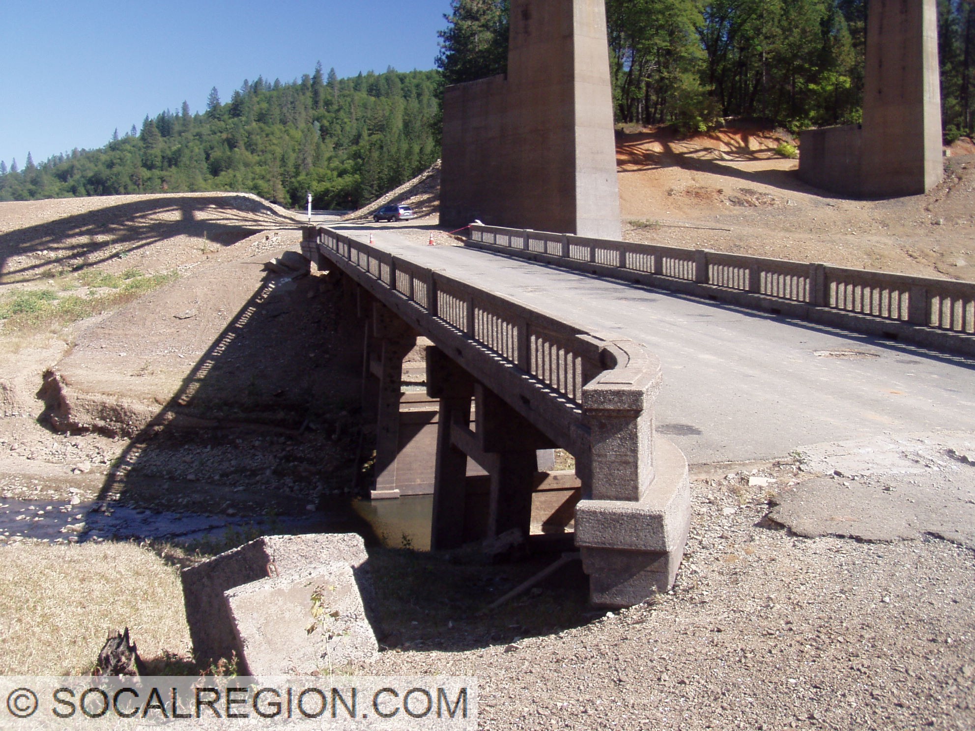
In October 2008, Lake Shasta was dropping to near historic lows. I took a trip up there to hike many of the exposed alignments. I also got out in the water in my wetsuit when I needed to. The whole trip was a lot of fun. Here are the photos from that trip.
Salt Creek Inlet and Lakehead Area:
Pit River Area:
Where US 99 goes into the lake on the south bank near the Pit River Bridge.
On Sunday, February 24, 2012, I went out for a ride to Campo on my motorcycle. I wanted to take some photos of the old sections of Hwy 94 and the weather was great for a ride. Starting out, it was a quick freeway ride to Campo Junction, where the two lane portion of Hwy 94 starts. That is where the fun begins. It was also where the first stop was, at the 1929 Sweetwater River bridge.
1929 Sweetwater River Bridge
After I left the bridge, my next stop was at a section of old concrete I had discovered on a previous ride. With a camera in hand, it was time to get photos and explore some more. I didn’t find any date stamps, but I did find lots of old striping. Still pretty cool.
1920’s concrete near Jamul
After Jamul, there was an old creek crossing with concrete I had found recently. It appears to be an Arizona type crossing instead of a culvert. The new crossing is now a culvert. I’m not sure its age, but I’m going to guess it is from the 1930’s. Also in the area is a neat bridge crossing Dulzura Creek at Otay Lakes Road. It was built in 1947 and has a nice sleek look.
Original low-water crossing on Hwy 94
1947 Dulzura Creek Bridge
In Dulzura, I stopped at a 1930 bridge which had bridge abutments near it from an even older span. I couldn’t quite tell what sort of a bridge the original one was, but was most likely wooden.
1930 Dulzura Creek Bridge at Dulzura
Further up the road at Cottonwood Creek, there are a few items of interest. The “new” Cottonwood Creek bridge from 1954 bypassed both the original bridge and large section of the alignment. Barrett Smith Road follows the old alignment up the steep grade out of Barrett Junction.
Cottonwood Creek crossing on Hwy 94 at Barrett Junction
At Dogpatch, Hwy 94 crosses the San Diego and Arizona Railroad for the first time under a 1915 bridge. Just after that bridge, there is another 1947 bridge. Adjacent to the 1947 span, there are abutments to an earlier bridge.
1947 bridge at Dogpatch
1915 Doigpatch UP where the San Diego and Arizona Railroad crosses
My last stop was Campo. I needed to fuel up and get photos of the bridge at Campo Creek. It is the last bridge with wooden railing on Hwy 94. After I stopped here, I headed back to town on Hwy 94. I enjoyed the ride and the scenery. It was the first time in a long time that I had stopped so many times on 94. The last few trips have been just riding or driving.
Out on a ride recently, I came upon a short stretch of original concrete from old Hwy 67. This roadway leads to San Vicente Dam and the townsite of Foster. I believe this concrete dates to the 1920’s, but I am uncertain. More research will reveal its age.
On Sunday, I went to the Redlands area to drop off a friend. I figured, why not see some old highway in the area and make the trip back more fun? So, after dropping him off, I headed over to Redlands Blvd. This is a section of old US 99 that still retains its concrete paving from the late 1940’s. I never really got any photos of it before, so it was good to see it still there. From Citrus Ave east, the roadway is more of an expressway, with a wide median and limited access.
After Redlands, the next section of old highway would prove a bit more interesting to get to. It was a short section of concrete paving, from the 1920’s most likely, and was located adjacent to the 10 freeway. I had to actually pull off the freeway shoulder to drive the short section. It was pretty neat, seeing as how this had been realigned so many times since that concrete was poured. I was hoping to return to the freeway by simply driving through. That idea was quickly thwarted when I found a tall curb at the shoulder. I had to back up and get on where I pulled off. So much for trying to be inconspicuous!
Redlands Blvd, “in town”
Divided section of Redlands Blvd, like an expressway.
Some of the concrete visible… seen just to the right of the shoulder.
More paving, both lanes now visible.
My next stop would be Robert Rd, near Cherry Valley Blvd. This section is threatened with removal or repaving as it is adjacent to a new large housing tract. So far, it is still intact. This nice concrete section dates to about 1928 and is one of the last sections of intact concrete around here. I took many photos here, hoping they wouldn’t be my last. The economic slowdown seems to have helped here, as the housing tract construction has slowed dramatically. At this point, I figured, I’ve gone this far… might as well go to the 60 junction and look around. So, I got back on the freeway, and took the San Timoteo Canyon Road exit. A frontage road heads east here, on the south side of the freeway. A portion of it is old US 99, complete with a 1939 bridge over San Timoteo Creek. Upon closer inspection of the bridge, I found that the eastbound I-10 bridge was also a part of old US 99. It was the original westbound bridge for the expressway, built in 1951. Now traffic is going the wrong way over it, from a historical context. One final stop was to be made, the old US 99 / US 60 / US 70 junction at the edge of Beaumont.
Short section of Roberts Rd that is now a driveway.
Roberts Rd, fairly pristine 1920’s concrete.
San Timoteo Creek Bridge from 1939
Old westbound bridge from 1950, now eastbound I-10.
I’d seen what appeared to be bridge piers and concrete approaches to an old bridge just north of the current SR-60. It turns out, that is exactly what they were. In 1936, the current westbound bridge for SR-60 (old US 60), was built. It replaced an earlier bridge, the one that I had been seeing pieces of. Today was finally my chance to walk around and see the old pieces. I was rather amazed at how much was left, considering how long ago it was all torn out. A fair amount of the eastern approach to the bridge remained, most of it buried under a thin layer of dirt. There wasn’t anything left of the western approach. I also got some photos of the exit sign for the 60 West from the 10 East. The sign was from 1960, and was overlaid with a SR-60 sign. Yes, there is a US 60 shield under there… just hope the overlay panel falls off at some point! After hiking around, it was time to head back. The approaching storm was getting worse, and the winds were picking up. I had a long drive ahead, and didn’t really want to do it in heavy rain. Thankfully, all I had to deal with was heavy winds and dust at times. I finally got to see some sections of old US 99 that I either hadn’t seen before, or weren’t sure were still around. More trips will be made up this way, just not during summer.
1936 Beaumont Overhead, now westbound SR-60
Remains of the earlier Beaumont Overhead
Some of the old approach still exists, with concrete.