Even in heavily built up Orange County, there can still be places where old highways can be seen. One of the best examples is located in Brea Canyon, where the Orange Freeway winds its way through open and undeveloped lands between Orange and Los Angeles Counties. Before the freeway, State 57 followed Brea Canyon Road. This two-lane roadway has changed little through here and has a few interesting features.
Old pipe railing and current 1930’s alignment.
Section of original concrete, bypassed in the 1930’s.
Former weigh station platform.
1939 bridge over Brea Creek.
Detail of the railing from the 1939 bridge.
Old concrete just past the lower 1930 bridge.
Last section of old concrete just north of State College Blvd.
In the early 1930’s, Los Angeles County began construction of an additional roadway over the San Gabriel Mountains via the East Fork of the San Gabriel River. The road, then known as the Camp Bonita – Prairie Fork Road, was about half complete with with four larger bridges and a tunnel, by early 1938. Work had progressed as far as “The Narrows” by 1938. However, the March 2-3, 1938 storms caused much of the roadway to be washed out. The project was then abandoned, leaving a large arch bridge stranded many miles upriver. The tunnel still exists as well, just north of the “Bridge to Nowhere”, though it has been sealed at both ends.
1936 arch bridge – The Bridge to Nowhere
1936 stamp on the arch bridge.
Looking over the arch bridge to the tunnel site.
Abandoned and partly destroyed bridge over the river.
Bridge over Cattle Canyon on the East Fork Road. This is similar to what the removed bridges north of here would have looked like.
1934 USGS Camp Bonita map showing the roadway completed to about 1 mile south of the “Bridge to Nowhere” site.
1940 USGS Camp Bonita map showing the now stranded bridge location.
In the 1955, a new road building project commenced in the canyon, first known as East Fork Road, then Shoemaker Canyon Road. This new alignment would stay high above the canyon floor until it got nearer to the “Bridge to Nowhere”, allowing that earlier work to come to some use. Progress on this roadway was slow, mostly due to poor funding. Convict labor was used for most of the project, similar to many other road building efforts at the time in Los Angeles County. Two tunnels were constructed as well. These still exist and are mostly intact. This project too was cancelled in 1976 , leaving another large scar in the canyon. This road is presently known as Shoemaker Canyon Road.
Stone railing along Shoemaker Canyon Road.
Looking toward the higher peaks of the San Gabriels along Shoemaker Canyon Road.
End of the pavement and open section of Shoemaker Canyon Road.
1961 and 1964 tunnels in view.
Partly graded roadway and tunnel along the “Road to Nowhere”.
Date stamp on the first tunnel.
Inside the longest tunnel, from 1961.
Grading along the “Road to Nowhere”.
Northern tunnel from 1964.
1966 USGS Glendora map showing the “Shoemaker Canyon” roadway under construction.
Today, the canyon is protected from future development through the Sheep Mountain Wilderness Area. Even without this protection, the geology of the canyon makes for a very expensive project. Maintenance would also be costly, as seen with State 39 through San Gabriel Canyon and above Crystal Lake. In time, all these structures and cuts will wash away, leaving the canyon with only bits of concrete and asphalt to show what was once here.
I took a trip recently to the Corona area to check out some of the old alignments of US 91. I had been there before, but it has been a long time. Starting from the Green River exit off of the 91 Freeway, I headed east along the south side of the freeway. Here, the roadways named Green River Road and Palisades Drive cover the pre-freeway alignment of US 91. This section is also a portion of the 1939 Prado Dam Relocation. This realignment took the highway out of the riverbed to the north and pushed it closer to the hills. A significant portion remains today relatively intact.
Near the Green River Road interchange, an abandoned portion of the roadbed is revealed by a 1939 culvert. The pavement has long since been removed. A portion of the old median, complete with curb divots, remains to the east. The best portion, however, is on Palisades Drive. This section has a fairly continuous old median, old bridges, wooden railing, and even a mile marker from Route 91. This whole section was bypassed in the early 1970’s along with a change to the 91 / 71 interchange.
Abandoned section of US 91 near Green River Road.
1939 culvert on the abandoned section.
Old raised median on Green River Road.
Section of Palisades Drive, restriped to two lanes from four. Old raised median and wooden railing are visible here.
Nice section of intact wooden railing.
Old Route 91 milemarker. Reads “091, RIV, mileage illegible”
On Sunday, June 16, I went on a motorcycle ride out toward Palm Springs. On Hwy 74 just east of Hemet, I stopped to inspect an abandoned concrete arch bridge to the side of the current bridge. The “new” span, where Hwy 74 crosses today, was built in 1929. This makes the abandoned span most likely from the 1910’s. It appears to have been longer, though the rest is long since washed away. I originally saw this bridge on a previous motorcycle ride, having missed it on every driving trip through here. It just goes to show that you see more on two wheels – be they motorcycle or bicycle wheels.
Last remaining arch
Evidence the bridge continued west. It looks like there may have been an additional arch span.
Looking east across the bridge deck toward current Hwy 74.
Current 1929 bridge across the river. Abandoned span is about 50 feet to the left.
Detail of the railing on the bridge. Note the 90 degree end to the railing instead of the curved ends used later.
After leaving the bridge, I headed east on Hwy 74 up into the mountains. The roadway was recently repaved, which was badly needed. The new pavement was quite fun to ride, even with the extra twisty passing areas. The tires seemed to grip the road better allowing me to ride faster than I did before. I didn’t originally plan to go all the way to Palm Springs, but somehow I decided “Why Not?” and did it anyway. It was rather hot while I was there, so I didn’t stay long. Leaving town was almost as difficult as dealing with the heat. Strong west winds, typical for the area, were blowing and made riding somewhat unnerving at times. The winds finally subsided once I got to the Beaumont area and temperatures decreased quite a bit as well.
Seven Level Hill on Hwy 74 heading into Palm Desert.
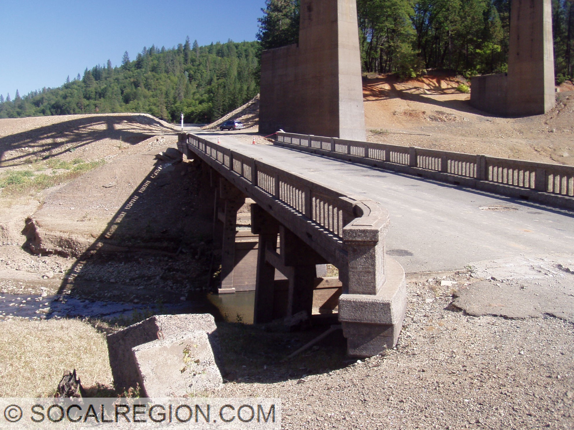
In October 2008, Lake Shasta was dropping to near historic lows. I took a trip up there to hike many of the exposed alignments. I also got out in the water in my wetsuit when I needed to. The whole trip was a lot of fun. Here are the photos from that trip.
Salt Creek Inlet and Lakehead Area:
Pit River Area:
Where US 99 goes into the lake on the south bank near the Pit River Bridge.